After our fun week in Moab we were looking forward to continuing the fun some 50 miles north near San Rafael Swell. We met our friends with the Colorado Western Slope 4-Wheelers club (WS4W) to do some more 4-wheeling. Our home base was Green River, Utah where we parked the RV at the KOA Campground and for 5 days we were off-roading in or near the San Rafael Swell.
San Rafael Swell, Utah
According to the Bureau of Land Management (BLM), the San Rafael Swell is part of the John D. Dingell Jr. Conservation, Management and Recreation Act of 2019 where Congress designated the San Rafael Swell as an Recreational Area (approx. 217,000 acres). The San Rafael Swell Recreation area features magnificent badlands of brightly colored and wildly eroded sandstone formations, deep canyons and giant plates of sandstone tilted upright through massive geologic upheaval.
We were lucky enough to drive among these massive geologic upheavals and take in the beauty of petroglyphs, pictographs, arches and historical areas in the five days we were there. Following are photos of some of the areas we visited.
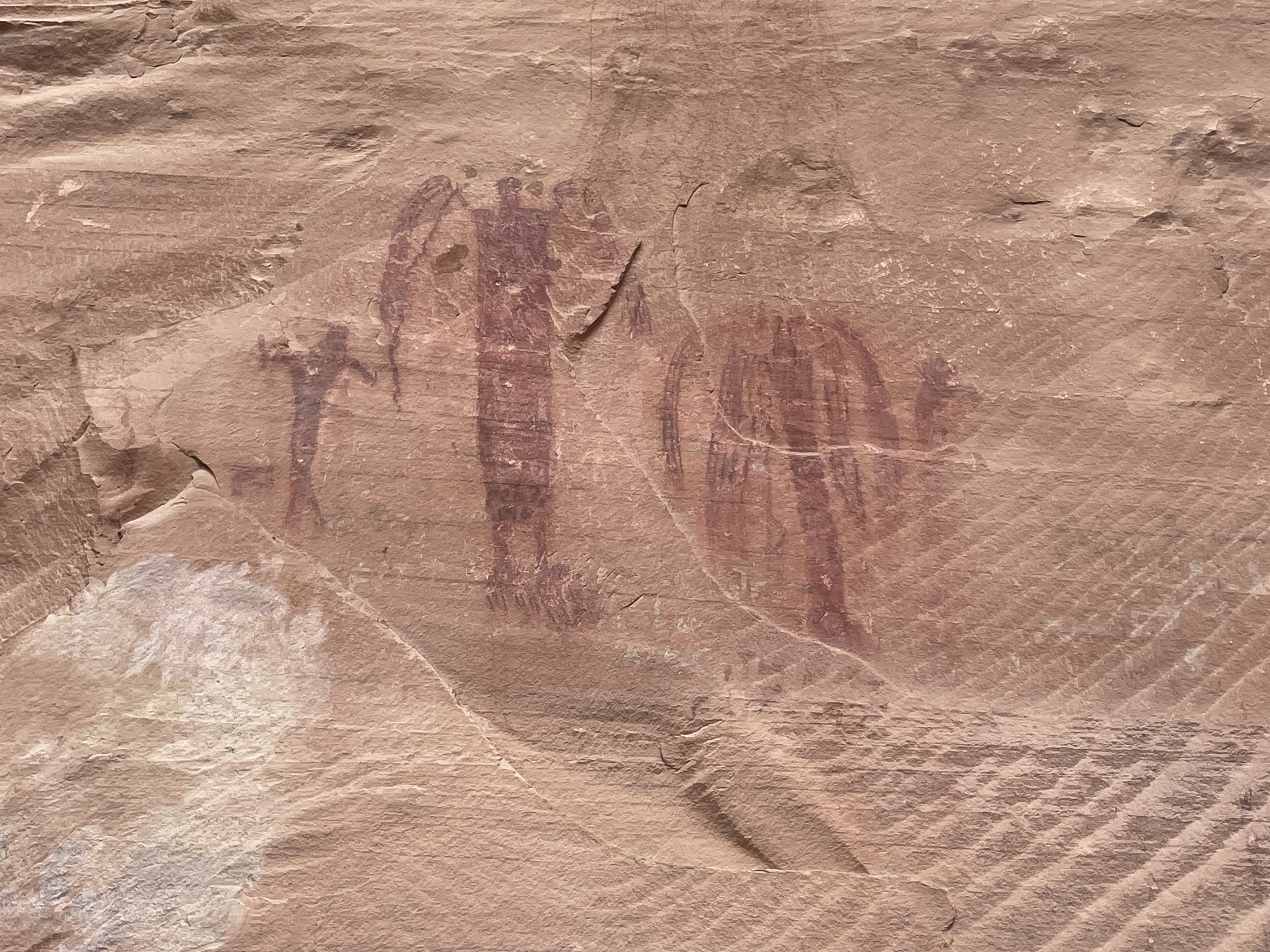
Black Dragon Canyon is named so from a pictograph with apparent wings and a long tail which looks like a dragon/dinosaur creature. When doing some research on the history of Black Dragon Canyon we found that a pictograph had a reputation as a "winged monster" when it was discovered by some amateurs. In the 1940's, John Simonson drew a chalk line defining his interpretation of a winged monster or dragon, and published a paper describing his methods. Decades later, a geologist said it resembled a pterodactyl, so the Young Earth Creationists started using this as evidence that Native Americans and pterodactyls lived at the same time. University scholars and research teams tested the dyes used in and around the 'dragon' and also used different light wave imaging to find there are five separate pictographs encircled by the white chalk outline (a bighorn sheep, a dog, a large bug-eyed anthrophomorph with a snake in his hand, a small man bent at the waist in supplication with his arms outstretched and a large sinuous horned snake). So the single "winged monster" pictograph has been debunked. All five pictographs are thought to be the Barrier Canyon style. Simonson had converted the small man pictograph into the head and neck of a dragon.
 |
The Black Dragon Pictograph
|
What were they saying, celebrating, mapping, 2000 years ago?
 |
| Our travels through the narrow ravine with massive canyon walls around. |
 |
The beauty of the red canyon walls and formations
|
 |
| The trail wasn't all flat ground but no problem for our Jeep. |
 |
| Great t-shirt to commensurate the day. |
On our way out of canyon and before we headed back to the RV for the night, the group made one last stop at 'The Sinkhole'. 'The Sinkhole' is roughly 30 feet in diameter and at least 25 feet deep. A group of four-wheelers found the sinkhole many years ago and reported it to BLM. We could not find any definite explanations why the sinkhole is located here but our guess is the underground gypsum pockets collapsed. I'm glad it has a fence around it to warn drivers.
 |
| Yep - it's a sinkhole. |
 |
| Group shot circling the sink hole. |
Day 2: Buckhorn Wash - We were so happy we were able to run Buckhorn Wash Trail twice with two different trail leaders. We had a great time on each trail and noticed different things both days.
 |
| The official Buckhorn Wash greeter. |
 |
The San Rafael Swinging Bridge was completed in 1937 by the
CCC. It is the only suspension bridge remaining in Utah. |
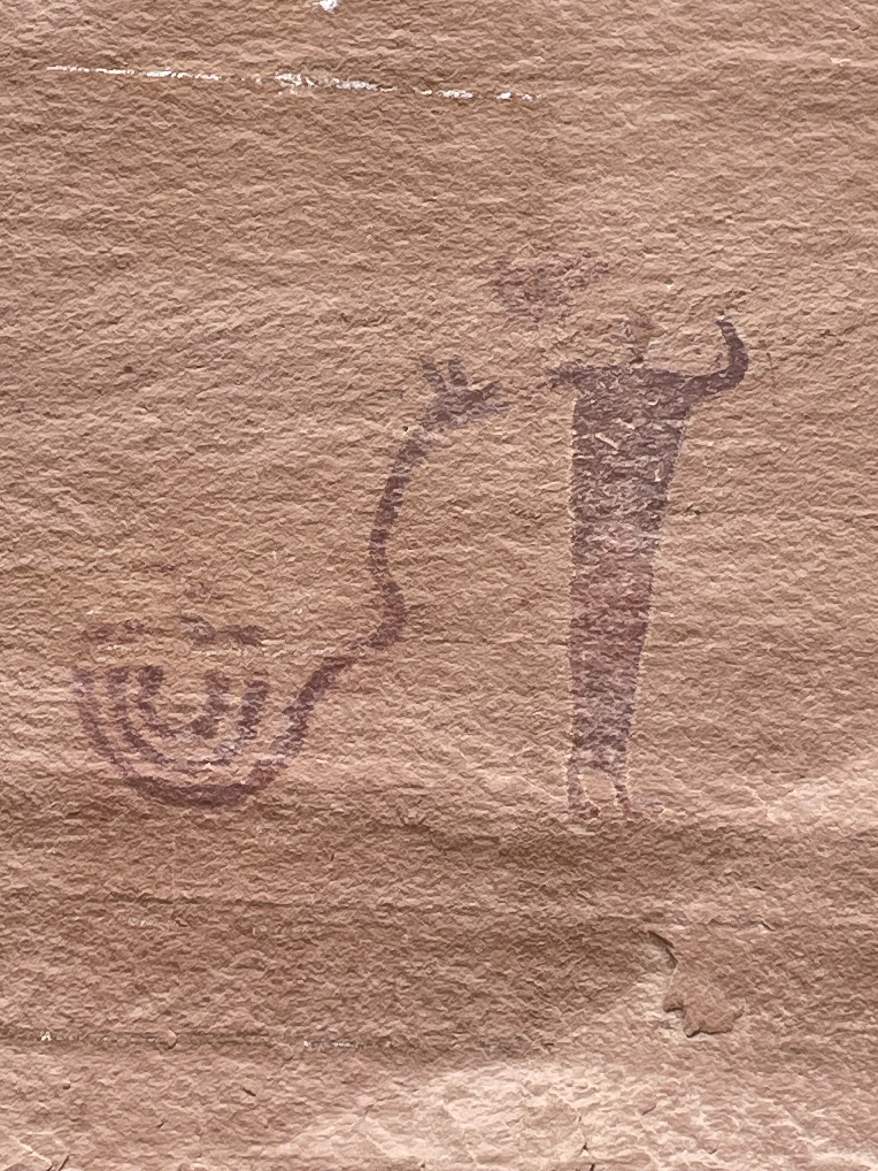
Buckhorn Wash Pictograph and Petroglyph Panel: The information boards indicate that two art forms and cultures are displayed on this panel. Some 1000 years ago the Fremont culture pecked figures into the rock called Petroglyphs. While 2000 years ago the Barrier Canyon culture people painted most of the panels images which are called Pictographs. It was very special to see both types of ancient drawings on the rocks.
 |
| Maybe Rain Angels? There is definitely fringe or wings being displayed. |
 |
| Coiled snake ? |
 |
| This artist(s) had quite the story to tell ! |
 |
| If we could just hear the 'story line' of these works of art. |
 |
| Petroglyphs at Buckhorn Wash Panel |
 |
| The group parked at Buckhorn Wash Panel |
Shortly after the Buckhorn Panel we stopped at a Dino Track - a three-toed track left by an ornithopod dinosaur that crossed a sandy beach that hardened and became the Navajo Sandstone over 180 million years ago.
 |
| Dino Track |
Plus we were made aware that there was another petroglyph panel around the corner from the dinosaur footprint which is not known or viewed by many. So off we went to find this allusive carving. After searching we finally found the petroplyph.
 |
Maybe a warrior or king ??
|
We continued to make our way to what is known as 'The Wedge' overlook where you have a great view of The Little Grand Canyon. Also all along this wedge were spectacular views of the canyons, mesas and buttes. This was the destination for the day.
 |
| View of the Little Grand Canyon |
 |
| Lunch spot with a view. |
On our way back into town we stopped at one of the MK Tunnels. Many articles indicate that in 1948 the Department of Defense (DOD) contracted with Morrison Knudsen Contractors, hence the name of the tunnels of Morrison Knudsen Tunnels, to drill underground explosive test areas and then conduct a series of tests utilizing surface-placed explosives. These tests would assist DOD in determining the depth and type of cover needed to protect against enemy attack, the effect of repeated bombing on underground structures and ways to improve the design of tunnel openings, etc. This particular tunnel is one of the smaller tunnels. It probably measured only 200 feet in depth.
 |
| MK Tunnel |
 |
| Jack exiting the tunnel. |
 |
Tunnel Dwellers. Pitch black tunnel but we managed after several
attempts to get a pretty good group selfie.
Eddie, Linnea, Jack, Alan, Deb, Stephanie |
On our way home we exited out another dirt road that had unique geology beauty. We don't know exactly what this layering is called but it was eye catching because of the multiple layers of white and brown sandstone.
 |
The geology rock layers are so interesting.
|
The final day of exploration we had fun driving Eagle Canyon, visiting Swasey's Cabin and finding more rock art along the way.
We started our day by visiting the Head of Sinbad rock art. More specifically referred to as the Skeleton Shaman panel. This is one of the best preserved ancient pieces of rock art in the world. In researching about the rock art we found out that scholars estimate the pictographs to be 2000 +/- years old. It is amazing that the paint/dye material the Barrier Canyon Native Americans used still appears so vibrant and fresh.
 |
| Skeleton Shaman art panel |
 |
| Barrier Canyon style figures with snakes in their hands. |
 |
| Interesting pot marks in the sandstone rock. Is that a heart I see? |
Next we made our way to the historic Swasey's Cabin. Let us start by giving you some history about the Swaseys. The Swasey brothers, Joe, Sid, Charley and Rod were some of the early cattlemen that explored the San Rafael Swell while running cattle here in the late 1800s and early 1900s. This is very evident because many of the features in the area have their name on it. In 1921, Joe Swasey built what is known as Swasey's Cabin in the heart of the Swell. The cabin was to be used as shelter by the Swaseys and other cowboys when running cattle in the area. Upon our visit, the cabin was 103 years old. It has been preserved for us to enjoy and the area is so picturesque. From what we have read Broken Cross Tower is located behind the cabin. On our ride into the area it sure looked like an eagle watching over the cabin to us. You decide.
 |
| Swasey's Cabin |
About 100 yards or so away was a historic refrigerator....no kidding..... it is called the Ice Box Cave. The cave walls were cool to touch and definitely had a cooler temperature than outside the cave. The walk- up trail flanked cervices, slot canyons and was snow lined when we arrived at Ice Box Cave. Snowball fight anyone?
 |
| We climbed through the snow to entrance of Ice Box cave. |
 |
Jack in one of the slot canyons.
Nearby the cabin was the Ice Box cave and various slot canyons. |
After viewing the cabin and the cave we continued driving through the very scenic Eagle Canyon where we arrived at Eagle Canyon Arch. Arches are one of our favorite things to search out. This arch has a span of about 12 feet and an height of 90 feet.
 |
| Eagle Canyon Arch |
Making our way out we stopped under the two Interstate-70 bridges for a break and also we had our sights on a geocache. Yes, we found it.
 |
| Interstate 70 bridges. |
All week we had so much natural eye candy that we were overjoyed to travel through this beautiful area. The San Rafael Swell area has so much to offer to the outdoor adventurer.
 |
Having fun on a very windy day hanging out with these ladies. Thanks for the memories.
Tina, Linnea, Ruth, Deb and Diana |
With another week of fabulous adventures completed it was time to head home. The next day we headed home via San Rafael Swell (State Rt 24 and 95) and eventually through Bluff, Utah. The scenery through the canyon lands of the upper reaches of Lake Powell and to cross both the Dirty Devil River Bridge and the Hite / Colorado River Bridge was 'red rock' spectacular !
 |
If you look closely the Hite Crossing Bridge over the Colorado River
can be viewed between the two closest rock formations. Photo taken
from front seat of motorhome as we moved on down the road. |
 |
| Viewing nature's masterpiece one mile at a time. |
Until next time - Life is a journey, enjoy the ride on a dirt road!
Jack and Deb


