UnCaged Travels

Monday, August 7, 2017

Mile High Jeep Club Annual All 4 Fun, Leadville, CO

Seven Days in Leadville, CO for All 4 Fun - the annual off road gathering organized by Mile High Jeep Club.


What do you get when you combine dirt, mountains, streams, old mines, ghost towns and hundreds of off road enthusiasts - a week of ALL 4 FUN!  We attended the Mile High Jeep Club (MHJC) Summer event called 'All 4 Fun' which was their 51st year of putting on this event which rotates around 4 or 5 locations each year.  We loaded up the RV Friday and arrived  at Leadville on Saturday to register and set up our campsite with about 300 other Jeep / off road lovers. They set up a large tent to gather everyone for raffle drawings, a couple dinners and vendor show to make it a family and group event and they do a good job organizing this event.

MHJC run about 20 different trails ranging from easy to difficult and each one running daily for five days.
 
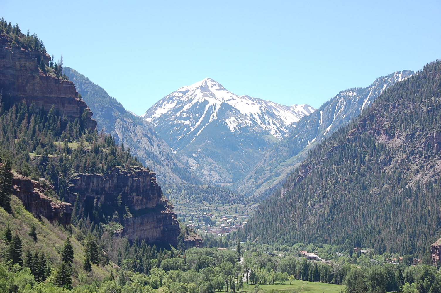
Thanks to our friend, Bill, we had a camping spot with plenty of room and great views.


1st trip: We started out with Clohesy (Cloyses) Lake (we found two different spellings for this lake & unsure which is correct) which was south of Leadville about half way to Buena Vista. It started out easy on dirt roads going past Clear Lake and up the canyon to Vicksburg and Winfield which are a couple preserved 1880's mining towns that, like a number of old 1880's towns/buildings, are being saved and restored and even being furnished with original items to promote the history of the area around Colorado.
 
Historic town of Vicksburg, CO:


Historic town of Winfield:


We did a couple creek crossing to start the trail.

Made it up to the lake at about 11,100 feet in elevation and very scenic.


2nd trip:  The second day we chose to adventure to Mount Princeton driving about 4 miles along a one lane shelf road.


One of the only true completely clear days and the views at 12,300 feet overlooking Buena Vista to East and the Collegiate 14'teener around and Mount Antero to the West.


Just another couple thousand feet up to the top of Mt. Princeton only accessed by foot.

 
After finishing the group run we drove to another 1880's mining town of St. Elmo, which is also in the stage of being preserved.


Following the creek up to St. Elmo, we enjoyed some great water / creek views.

3rd trip:  The third day we signed up for the  Mount Zion trip and we weren't disappointed with the great views over looking Leadville and Turquoise Lake. (Even though it was a little hazy)


Looking down on Buckeye lake from about 12,200 ft for lunch break.

 
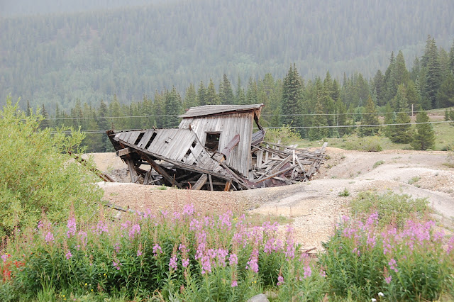
Our bonus trip for the day was taking a road less travelled by exploring and found this old miners cabin.

 
4th trip:  The fourth day was a run called Birdseye Gulch and up to Mosquito Pass. Starting up the shelf road looking down on Birdseye Gulch and Leadville.


Mosquito Pass is the highest drivable pass at 13,185 ft, and as we drove slowing up to the summit a cold front blew through and we were driving through cold wind, snow and hail for a few minutes.


About 2 miles over the pass we stopped at the North London mine and tram house.

 
After coming down we did some more exploring of the old Leadville mining area and checked out some old cabins.

Interior of one of the buildings equipped with stove and original ceiling cloths and old wall paper.
 
The area had an abundance of old mines that dot the area which were fun to explore.


Final trip:  The last day we went on Half Moon Creek trail.  This trail had water crossing, great views and amazing mills and mines throughout the area.


At the head waters we came on to the Champion Mill site which is one of the largest mills around in great shape.

It started in the 1880's and ran up in to the early 1900's and still has equipment inside the mill.


We then went on up to the Champion Mine at about 13,000 ft. where they ran a tram system to get the ore down to the mill and a view looking down on Independence Pass road.


The inside of the mine cabin / bunk house with the stove still in place.

Nice view from the mine cabin.
 
Some of the wildlife and flowers on the trail


A view back down on the large mill building

Coming off the trail at the water crossing.

The event ended on a week of great trail runs and we had to head home. Until next year  which is being held at Silverton, we had fun and thanks to MHJC for the great event.
Hope you enjoy the photos.       
 
Happy travelling ! 
 
Posted by Uncaged Travels at 7:24 PM No comments:
Email ThisBlogThis!Share to XShare to FacebookShare to Pinterest

Sunday, August 6, 2017

Jeep ride through Engineer Pass near Silverton, CO

Engineer Pass, Silverton, CO

After enjoying our mine tour and breakfast at the Bachelor-Syracuse Mine we headed toward Silverton but made a detour near the Red Mountain Pass on a bypass at the Ghost Town of Ironton to explore the standing old buildings.  Settled in 1883, within three weeks three hundred buildings were being built.  Ironton was a major transportation junction between Red Mountain and Ouray in addition to having some of its own mines. Ironton had a peak population of over 1000 and had two trains arriving daily from Silverton. There were many chain stores from the nearby cities of Ouray and Silverton. The town lived into the first part of this century and has slowly faded since then (Ghosttowns.com).


And some great scenery around the area.


As we continue to explore we drove by some of the old mines in the area with great views of the area.


We stopped at Yankee Girl mine that was one of the richest silver producers in the area where they hit a natural column of silver ore so pure that it didn't have to go to the mill and went straight to the smelting room for melting into ingots.


Then after lunch in Silverton, we headed up the road to Animas Fork and the start of Engineer Pass.


 We saw some of the local wildlife in a bunch of the Marmots running across the road ahead of us.


And this male grouse that was strutting his stuff for a hen sitting in the bushes next to him beside the road and they didn't react to us driving by...


As we made our way up Engineer Pass we noticed we had the road to ourselves which gave us time to stop and enjoy the area and take photos.


 Once we took some photos along this tall snow drift we then continued down the other side and into Lake City and back to the house in Montrose.

 We had a great day out exploring the back roads even thou none of it was 'rough' four wheeling !

 More to come as the summer goes on.... Enjoy your travels !
Posted by Uncaged Travels at 5:32 PM No comments:
Email ThisBlogThis!Share to XShare to FacebookShare to Pinterest

Sunday, July 23, 2017

Weekend Adventure at the Bachelor-Syracuse Mine Tour

June 2017 -

The Colorado snow is beginning to melt and the off-road trails are beginning to appear.  We had reports from the various organizations are some of the lower trails were open but warned it might be wet and muddy.  So we headed out to see for ourselves.
 
First on our list was to visit the Bachelor-Syracuse Mine for the breakfast and tour.  We've heard so many good reviews on the both the breakfast and tour that it was on list to do and we did not make time last year for it.  So both of us are hungry for food, mining history and off-roading we headed to Ouray from Montrose.
 
We drove US 550 to the turnoff for County Road 14.  Of course the mountains are beautiful and we experienced an awesome view of Ouray while driving up to the mine.


Bachelor-Syracuse Mine History
During the main silver rush in Ouray (1876 to 1893) most of the silver mines were located up Box Canyon, up Canyon Creek in Yankee Boy and Imogene Basins, and around Ironton and Gastun to the south of Ouray. One other area was north of Ouray around what became known as Gold Hill. There was enough gold at the site to survive the Silver Panic of 1893. The Bachelor mine was claimed in the early 1890s by three bachelors, C.A. Armstrong, Frank Sanders, and George R. Hurlburt. Seeing as how none of them were attached, they settled on the name Bachelor Mine. It was a high producer and eventually bought out other claims in the area. The main shaft drilled downward from the top of the hill and eventually reached over 2000 feet into the mountain. As the shaft got deeper, ground water began to flood the mine and it became increasingly expensive to haul every ore bucket up out of the mine through the shafts to the top of the hill. A drainage adit was drilled from the east, which allowed the mine to go even deeper. In the 1920s, another adit was needed to come in from the west into the bottom of the mountain to drain deeper water and allow the ore to be removed more easily. It was hoped that the adit would pay for itself by encountering new ore bodies along the way, and it was named the Syracuse Tunnel since the money to build it was raised mostly in Syracuse, New York.


Oops - we didn't get any photos of our breakfast but it was delicious.  I picked the Tiny Breakfast with 1 egg, bacon, potatoes & toast and Jack ordered the Big Breakfast which was 2 of everything I had plus biscuits & gravy.  We would recommend getting there early before the tour and fill your stomach with good food.

Let the tour begin -


Today, the mine tour begins at the mine opening. We walk in about 1500 feet after suiting up with hard hats and I also elected to wear the yellow rain slicker. When the tram was running, the tour went in 3500 feet, but this deeper tour is no longer allowed for safety reasons. As we walk inside along the tram rails that use to carry visitors into the mine the temperature gets a little cooler and damper with water dripping from the ceiling in places and a steady stream of water flowing out of the mine in a ditch to the right of the tracks.

While in the mine our guide told us about the history of the mine, showed us how the pneumatic drills were used to hammer out a series of holes in the face following a pattern of concentric circles. He even turned the lights off and lit candles so we could experience the actual lighting conditions used in the mine.


Tunnel moisture forms strange mineral formations on walls of tunnel.


So if you are in the area we recommend the Bachelor-Syracuse Mine Tour.  The next post will continue with our off-road adventure on this day through Red Mountain trail, Silverton, CO and Engineer Pass trail.

Until next time - Enjoy your adventure!
Posted by Uncaged Travels at 10:22 AM No comments:
Email ThisBlogThis!Share to XShare to FacebookShare to Pinterest

Sunday, June 25, 2017

Easter Jeep Safari 2017

Fun in Moab, Utah

at Easter Jeep Safari 2017


April 8th - 16th was a week packed with Jeepin' fun.  This was our 4th year to attend the Easter Jeep Safari organized by the Red Rock 4-Wheelers club.  Thousand of jeeps and off road vehicles sign up to participate in a number of trail runs known throughout the Moab area.  The scenery is made up of beautiful red rocks.  The Moab area is also known for Arches National Park, Dead Horse Point State Park and Canyonlands National Park.  With or without a 4-wheel drive it's well worth a visit.  The Easter Jeep Safari is also a great time to ooh and aah over all types of vehicles, from customized rock crawlers to the older seldom seen classic Jeeps.

We started our trip leaving Scottsdale on Saturday morning and not wanting to push it to make it all the way in one long 10 hour day, we stopped and spent the night in Bluff, Utah at the Cottonwoods RV park.  This gave us the chance to explore the area that we've driven through a number of times but never took the time to stop.  We found this rock formation called the locomotive rock. 


We found the Sand Island Petroglyph site and were able to see the many years of natives applying their art and stories to the rock walls


After a great morning exploring in Bluff, we headed on to Moab which was just a easy 2 hour drive on up the road and get checked into our spot in Moab.

We once again stayed in the Moab Rim Campark at the South end of Moab.  The park sits above Highway 191 which gives us a birds eye view of the rigs as they come and go from town.


 View from our RV site - LaSalle Mountains


We signed up for three club sponsored trail runs.  We enjoyed Dome Plateau, 3-D and Hells Revenge trails.  Below is a photo from Dome Plateau and one of a number of arches seem on this run.


A stop along the way on Dome Plateau trail was Cow Springs which had these large natural caves in the rock wall face and a natural spring coming out one which the local ranchers used to water a cattle pond.


Hells Revenge trail was a true 'Slickrock' trail and offered some good four wheeling challenges with tall near vertical climbs in which the 'lockers' had to be engaged but the JK accepted and passed all the challenges put at it all week!


On days in between trail runs, we like to explore on our own around the Moab area and this year we checked out Deadhorse State Park which is just Northwest of Moab and over looks the Colorado river and great views of the Canyonlands beyond for as far a one can see.  We could see the famous plateau and cliff named 'Thelma & Louise Cliff' which was where the movie scene were filmed where Geena Davis and Susan Sarandon drove the '66 Thunderbird over the edge at the end of the movie.


On the way back from Deadhorse State Park, we made a back roads detour and found Gemini natural bridge arches which are two arches side by side in the same rock but are separate arches as they have a large gap between them and we were able to walk across the tops of them.  In fact in the years past, they use to allow you to drive down and across them and actually park your Jeep on the top them.  Walking across was good enough for us!


We enjoyed our week in Moab filled with Jeeps, trails and beautiful scenery.  
Sign us up for next year.  

Until next time - Enjoy your adventure.
Posted by Uncaged Travels at 12:04 PM 1 comment:
Email ThisBlogThis!Share to XShare to FacebookShare to Pinterest
Newer Posts Older Posts Home
Subscribe to: Posts (Atom)

About Us

My photo
Uncaged Travels
Jack and I are enjoying our retirement and we are loving the freedom to travel in our motorhome so we can experience the outdoors by hiking, 4-wheeling or taking time to get 'uncaged' from our past working lives.
View my complete profile

Blog Archive

  • ▼  2025 (3)
    • ▼  May (2)
      • The Red Hills of Utah - Kanab Utah
      • Moab, Where the scenery never gets old.
    • ►  April (1)
  • ►  2024 (2)
    • ►  April (2)
  • ►  2023 (7)
    • ►  September (2)
    • ►  August (1)
    • ►  May (2)
    • ►  April (1)
    • ►  March (1)
  • ►  2022 (2)
    • ►  April (2)
  • ►  2021 (3)
    • ►  September (1)
    • ►  August (1)
    • ►  April (1)
  • ►  2020 (5)
    • ►  September (2)
    • ►  August (2)
    • ►  July (1)
  • ►  2019 (10)
    • ►  October (1)
    • ►  September (3)
    • ►  August (1)
    • ►  July (2)
    • ►  May (2)
    • ►  January (1)
  • ►  2018 (7)
    • ►  October (1)
    • ►  September (2)
    • ►  August (2)
    • ►  April (2)
  • ►  2017 (6)
    • ►  October (1)
    • ►  August (3)
    • ►  July (1)
    • ►  June (1)
  • ►  2016 (11)
    • ►  October (1)
    • ►  September (2)
    • ►  August (2)
    • ►  July (4)
    • ►  June (2)

Our Uncaged Family

Our Uncaged Family
Angel's last adventure was January, 2017. We miss our travel buddy.

2013 Jeep JKU

2013 Jeep JKU

2003 National Motorhome

2003 National Motorhome

Blogs we follow

  • ADVENTR.co » // Adventures and Photography from the Colorado Plateau, Rocky Mountains & Beyond
    Serpents Trail: The Crookedest Road In the World
  • good-times-rollin
    Goldwater Lake
  • GoneByRV
    Black Canyon of the Gunnison, Hiking and Touring

Please join us as Followers

Simple theme. Powered by Blogger.