Friday, July 1, 2016

Ophir Pass & Owl Creek Pass Jeep Trails

June 26, 2016 - Our next Jeep adventure into the San Juan Mountains near Telluride, CO was the Ophir Pass Road.  This road was originally established as a wagon road between the mines around Ophir and Telluride to Silverton.  After the Rio Grande Southern Railroad was completed in 1890 the road was only used as a time saving route for light wagon traffic. 
 
We had received a notice about two weeks ago that the Ophir pass had been snow plowed and was open.  We also had read and heard that even after the road  was plowed you would possibly drive through snow walls up to 20 feet high at the summit.  We did not want to miss the opportunity to experience such a trail. 

You can run this trail from either Silverton area or Telluride area.  We elected to start from the Telluride area via Highway 145 and then turning off at County Road 630 from the Telluride side which changes into County Road 8 on the Silverton side, toward the Town of Ophir. According to the town web site, the Town of Ophir was established in 1881 and sits at approximately 9,700 feet surrounded by 13,000 foot peaks. The Town has 74 homes with roughly 180 residents. Once a bustling mining town, Ophir is now a family community filled with outdoor lovers.


Along the way there are a number of mines located on the mountainsides.  Many have been wiped out by the weather and avalanches which abound in this area.


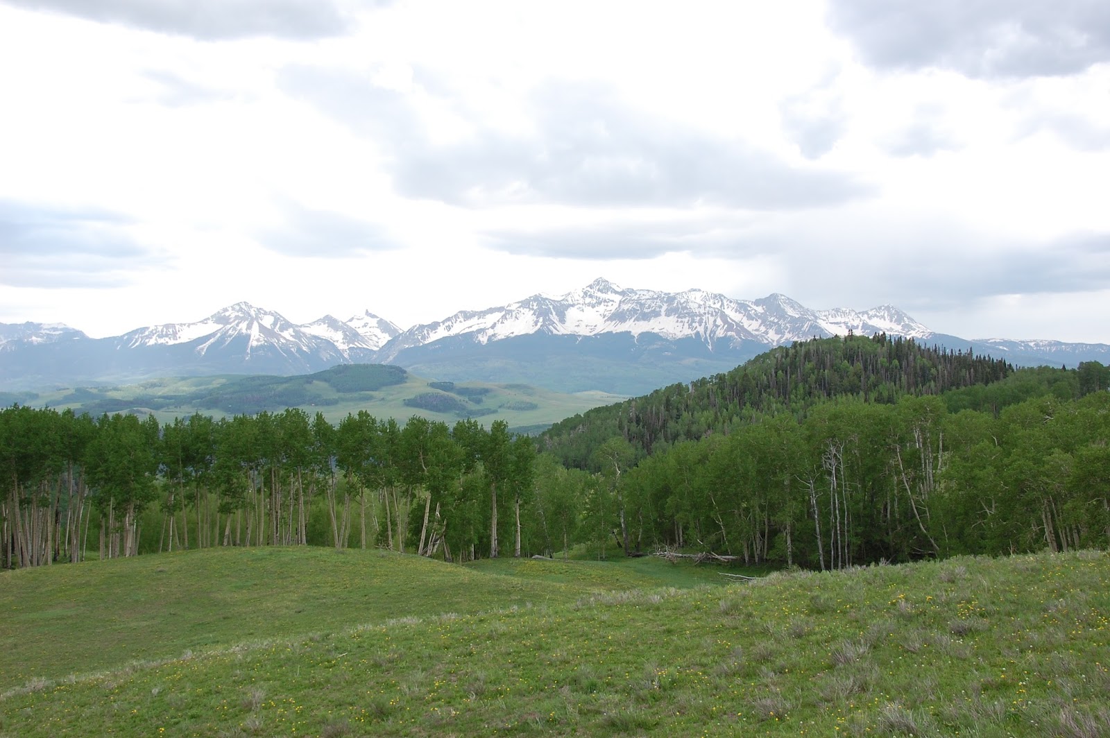
Once we drove through the aspen lined road we came upon the very narrow, rocky shelf part of the road. The shelf road is not wide enough to have vehicles pass each other. So it was a good thing that we could see all the way around the 1/2 mile shelf road to make sure there are no vehicles on the road so off we went.  We stopped a couple times for photo opts of the Ophir valley and the beautiful surrounding mountains.


Taken from the shelf road.  Town on Ophir in valley
 
Shelf road


Once safely on the other side of the shelf road we were close to the summit and the well known snow walls.
 
Shelf road in the background


We had a fun time driving through the snow walls and even watched some snow boarders with dogs cruise down to the road from above almost landing on the Jeep as Jack drove through it while I took photos.
 

You can barely see the snowboarders in the snow above the road.


We made it to the very rocky summit at 11,789 feet.
 
 
After the summit the road drops down to the Red Mountain basin and eventually connects to Highway 550.


Once reaching Highway 550 we decided to go to Silverton, CO for lunch and eat at the well known Handlebars Restaurant.  The service was friendly and the owner of 26 years came to our table to give us the history of the building which included a bowling alley, bank, and hardware store.  We loved our sandwich and Peach cobbler dessert.


After lunch we headed to Ouray, CO and then home - but wait - there's more !!!!
 
As we passed by Ridgway on the way home, we saw a sign at a dirt road turn off that sounded like it was calling our name and tugging on our steering wheel...Our side trip included a trail called Owl Creek Pass, a 1885 cattle-drive trail. This road included about 46 miles of scenic and popular drive over Owl Creek Pass and to Silver Jack Recreation area.  As many areas around Ridgway, CO boasts, this area is also known as an area where scenes from How the West Was Won and True Grit were filmed. Along this route winds through national forest and river basin country.

The peaks of Chimney Rock and Courthouse Mountain stand strong in our view most of the climb up the Owl Creek Pass road.   As typical on many Colorado roads, this road was lined with tall white-barked aspen trees, spruce and fir, rivers, reservoirs, and seas of wildflowers.


After the summit we make our way to the 325 acre Silver Jack Recreational area.  The Silver Jack Reservoir is remote and few services are available.  There are campgrounds with toilets but there are no RV hookups and literature says no reservations are accepted.  The lake/reservoir is beautiful and quiet as only hand-propelled watercraft are permitted on Silver Jack Reservoir.  Once we soaked up the beauty of the lake and area we head home.


Lots of scenery throughout the day.  We thoroughly enjoyed our two Jeep trails.
 
 
'The World is big and I want to have a good look at it before it gets dark.'  John Muir


Saturday, June 25, 2016

Last Dollar Road, Colorado - Jeep Trip


It was my turn to drive the Jeep for the weekend so I researched jeep trails in the Colorado Backroads & 4-Wheel-Drive trails guide and decided that the Last Dollar Road was my kind of trail.

The Last Dollar Road is located between the towns of Ridgway and Telluride, CO.  We drove about 12 miles from Ridgway at approximately mile marker 12 on Highway 62 where we saw a small Forest Service sign at the turn off saying ' Last Dollar Road'.  I should mention that Highway 62 from Ridgway, CO offers massive views of the Sneffels range part the San Juan mountains in the area and are worthy of a stop at the Dallas Divide pullout. 

Spoiler Alert:  There are a lot of scenery photos.
 
Welcome to Last Dollar Road


 Last Dollar Road looking at Hayden Peak 12,967ft (left) and North Pole Peak 12,208ft (right)

 
Along with beautiful views around every corner this area also has cowboy ranching history known as  the Last Dollar Ranch.  It contains approximately 392 acres that borders the 13,000 acre property owned by clothing maker Ralph Lauren.  In the past years the ranch has been used as a location for numerous ads for Anheuser-Busch, Coors and Marlboro.
The Last Dollar Ranch Gate.  Hayden / North Pole Peaks in the background.


We saw abundant wildflowers along the road
Mountain Lupine


Can't resist taking photo of old buildings


Aspen lined road


Looking west into the San Miguel River Valley

After reaching a summit at approx. 10,700 feet we started to make our way slowly down the slightly steep road overlooking the large meadows dotted with pine and aspen trees.


Meadow

 
Once we drop over the summit we were greeted by the view of Wilson Peak.  At 14,017 feet Wilson Peak is the highest point in San Miguel County and the 48th highest Fourteener.  Other than being ranked as a Fourteener, Wilson Peak is recognized for another reason and our beer drinking friends may know this bit of trivia.  Wilson Peak is on the Coors labels. 


Wilson Peak slightly to the left.


Once again, we can't resist taking photos of old buildings.  If only we knew the history of the buildings.


We knew that the Last Dollar Road was an old mining & sheep herding road between the Ridgway and Telluride area but we never imagine that they needed to fill up along the way at an old Conoco gas pump on the trail. 


We gradually leave the wildness area and enjoy the short drive through million dollar homes sites overlooking Telluride with the ending point being the Telluride Airport.
 
This Jeep trip was easy driving with awards of abundant scenery, history, flowers and aspens. We plan to return in the Fall for the fall colors.  Can't Wait !
 
The mountains are calling and I must go - John Muir


Monday, June 6, 2016

Sutton Mine Trail Hike - Ouray, CO

Ouray, CO is a beautiful area surrounded by mountains and a number of great easy to challenging hikes.  Jack and I love the area to 4-wheel and also hike.  In honor of the National Trail Day we decided to hike the Sutton Mine Trail to the remains of Neosho Mine. From the trailhead the hike is approx. 2.2 miles to the Neosho Mine.  We had viewed the mine and the well known 'Antique Store' from the highway with binoculars and had said we wanted to get to that mine some day.  So today is the day.


Sutton Mine Trailhead
 

The hike started out as steep switchbacks that worked the legs and lungs. However, the first overlook, Ouray Overlook, was awesome.


From the overlook the hike continues with more switchbacks and continues on an upward slope.  This hike had very nice views of the Million Dollar Highway below, the Amphitheater above and surrounding mountain views. 


Surprised to see cactus


Wildlife on trail


We made it to the Bear Creek Overlook in about 1.7 miles from the trailhead.  Just past the overlook (.3 miles) we found a wonderful rocky million dollar view spot to stop for a snack and enjoy the scenery plus take a much needed rest.


We crossed two 'cold' streams where we soaked our cool cloth to refresh our over-heated face and neck.  There's nothing better than the sound of a mountain stream waterfall.


We had a magnificent view of the Bear Creek Falls far below the trail.  That bridge/highway pull- over spot is where we first spotted the mine and decided we wanted to walk up there someday.


As we entered the Neosho Mine area we were greeted by well preserved storage buildings, the 'Antique Store', blacksmith shop and boardinghouse. FYI - there is really no operating Antique Store.


 The Neosho Mine is not safely accessible but the area is spotted with ore carts, tracks and cables.


This hike was approximately a 4 mile roundtrip hike that for us was strenuous up the switchbacks and then mostly moderate hiking with some easy areas.
 
Thank you for viewing.  Enjoy your day !