Friday, September 20, 2019

Capitol Reef National Park near Torrey, Utah

Capitol Reef National Park.
August, 2019

On our Utah National Park tour the next park to visit was Capitol Reef National Park near Torrey, Utah. Capitol Reef NP was established in 1937 and became a park in 1971.  The name of the park was derived from the landscape which is called the Waterpocket Fold (a 100 mile long barrier of rock that obstructed early travelers like a barrier "reef") and a sandstone feature that resembled the US Capitol. - hence Capitol Reef. This area was so remote and unknown that it was the last area to be mapped in the United States in 1870 by John Wesley Powell after rafting through the Grand Canyon.
The 'Capitol' part of Capitol Reef
The Waterpocket Fold (uplifted sandstone barrier) 'Reef'

There is a variety of things to do at Capitol Reef from exploring the historical town of Fruita, taking a 8 mile scenic drive within the park or hike to arches and admire petroglyphs.

 We first explored the historic town of Fruita where we bought a couple of world famous fresh baked pies and cinnamon rolls at the Gifford House.  You can see where our priorities are!  The historic Gifford House now consist of a small store and museum. The exhibits describe the Mormon pioneer history of the area. The Mormons settled here in the 1880's because the land was fertile with access to water from the Fremont River.  After the 1920's Fruita was abandoned and years later the Park Service would refurbish some of the old building and take care of existing orchards and replant others. Now there are almost 3,000 trees including apple, peach, pear, apricot cherry and plum. During our visit the peaches were so close to being picked but we had to move on. (But the pies and cinnamon rolls were delish)


The Gifford House as it stands today

The 8 mile Scenic Drive offers a mostly paved route through the heart of the park where it displays red rock views, sandstone cliffs that are in every color that have been formed in every kind of shape making it a very pretty drive.  Once the pavement ends you can take a couple of dirt roads to popular trailheads, arches and the Grand Wash road which was the pioneer's wagon trail through the 'reef' down a narrow canyon as evidenced by pioneers signing their names as they passed by at the turn of the century. (Some of the cowboy signatures were uniquely displayed by bullet holes from gun shots.)


Entrance into Grand Wash

The narrow Grand Wash which was the pioneer wagon trail

In the Grand Wash Narrows, early travelers signed the walls


Cassidy Arch
We did a short hike to Hickman Bridge. This 1.8 mile RT hike began at the Fremont River and quickly meandered up a rocky and scrubby mountain before it leveled off and descended into a sandy ravine to the bridge.  The loop trail ran underneath the bridge offering views from both sides plus view of the canyon/ravine we just walked through.

Hickman Bridge casting a shadow below it

The bottom side of Hickman Bridge as we walked under

The fertile valleys of Capitol Reef like many of the canyon lands of the Southwest were inhabited by the native peoples many years earlier (500 to 1300 AD) and left their images and stories for us to view hundreds of years later in the form of petroglyphs.   When traveling in the Southwest, we've learned to keep an eye open when looking up the canyons and rock cliff faces and you might find a hidden house or granary among the rocks that is a 1000 years old.


Granary found hidden in a sandstone ledge
We had read about a 64 mile dirt road through an area called Cathedral Valley where 4WD was recommended  with a bonus of a river crossing (sounds like this road is made for us and the Jeep!). This road had a diverse change of landscape with a number of overlooks the view the  colorful cliffs, towers, red rock formations and some very unique finds along the way. 


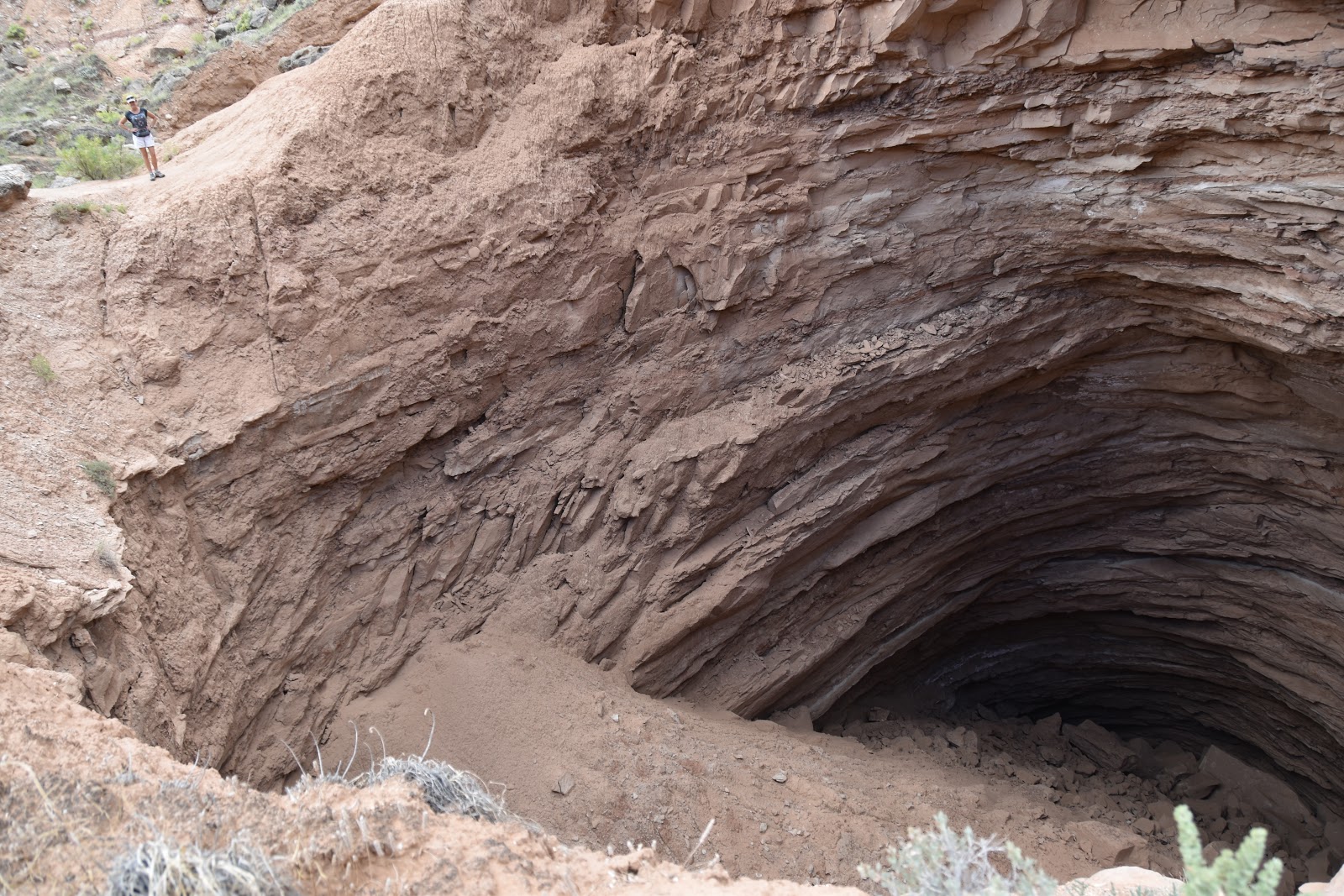
Gypsum Sinkhole 100 feet across and over 200 feet deep

Hoodoos watching us

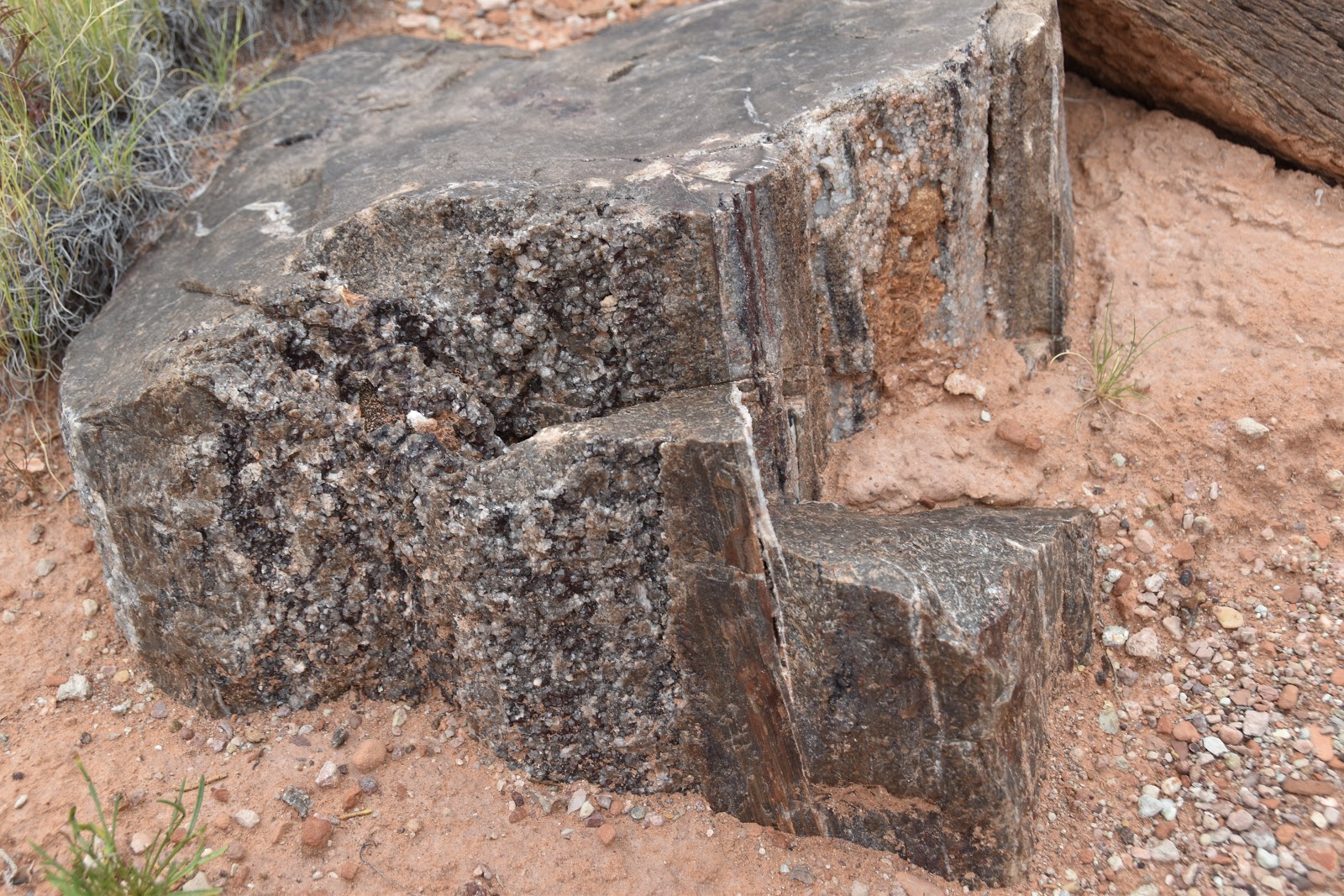
Glass Mountain gypsum crystals (selenite).  The crystals were actually very shiny and glassy .

Glass Mountain pushed up through the desert floor

Temple of the Sun and Temple of the Moon (to the left)

As we cruised along down the lonely dirt road taking in all the scenery we came upon this mirage in the middle of nowhere (actually a cattle watering trough) and by it was an antique truck and well drilling rig.  It had drilled it's last well many years ago and now it stands as a monument to its past.  It was so neat and part of the 'West' history for the area.


We enjoyed this area but it was time to move on to Cedar Mesa in search for a little cooler weather and more of the ancient ones.

Thanks for joining our adventure.  Until next time - Happy Traveling


Thursday, September 5, 2019

Boulder Mountain and Grand Staircase-Escalante areas - Continuing our summer adventure


Boulder Mountain - Grand Staircase /Escalante area - August, 2019
Our journey continued as we ventured from Bryce Canyon NP eastward along Utah Scenic Byway 12 to our next camping spot on Boulder Mountain between Boulder, Utah and Torrey, Utah.  Utah Scenic Byway 12 afforded many terrain changes and different rock formations along the way including driving over a section of road that was called ‘The Hogback’.  Fairly named because the road is along a thin razorback ridge of slick rock and drops off steeply on both sides of the road.  It was slow going but the scenic beauty of the canyons, creeks and formations were incredible.

Aerial of Hogback - compliments of the internet
As Scenic Byway 12 meanders up the southeast side of Boulder Mountain the temperatures became cooler and once again we  found our camping spot at about 8,700 feet in elevation with the low 80s during the day and 50+/- night time temps. Boulder Mountain encumbers 50,000 acres which covers half of the Aquarius Plateau (an uplift along the Colorado Plateau) making it the highest forested plateau in North America at roughly 11,000 feet.
Boulder Mountain Camp spot


Nosey neighbors visited everyday
 A trip to the Wildcat ranger station loaded us up with off-road maps, new places to see and a homemade lemon and cranberry muffin for the road thanks to the ranger hosts. Yum!  Some of the exploring took us over some of the roughest 4-wheeling roads we experienced so far this trip but the reward was plentiful with mountain lakes, aspen trees and breathtaking vistas of the Capitol Reef NP area.
 

Good four wheeling up to 11,000 ft elevation Fish Creek Lake


Great mountain wildflower were everywhere
 
An interesting side trip between Boulder and Escalante found us on Forest dirt road 153 called the ‘Hells Backbone’.  So named because in some areas the road follows a narrow ridgeline that barely separates the sheer drop offs on either side. The road was built by the Civilian Conservation Corps in the 1930's and was built to connect the towns of Boulder and Escalante, Utah.  Even though the bridge was been rebuilt we could see the timbers from the original bridge underneath the newer bridge.  The single lane bridge lies about halfway along the road. From the bridge we looked into Box-Death Hollow Wilderness.  The whole road meanders from high desert to high country maxing out at 9,200 feet.


The Hell's Backbone One Lane Bridge


Not far from our camp were the well known Lower Calf Creek Falls. The falls are fed by water from Boulder Mountain but are officially located in the 'slick rock' area of the Grand Staircase-Escalante National Monument and are considered a desert oasis boasting a stunning 126 foot waterfall.  We decided to tackle this 6 mile route trip hike even though the temperatures in this area were in the high 90’s.  Crazy right? We followed a stream the majority of the way which gave us some refreshing resting time during our hike. Along the trail we spotted pictographs and granaries left from the Anasazi natives which just added to the specialty of this hike. The climax, of course, was the waterfall where we stayed for an hour or so to eat our lunch and enjoy the coolness of the falls.
 
Pictographs on the canyon walls
Anasazi grain storage from over 800 years ago


Lower Calf Creek Falls


Lower Calf Creek Falls
Our lunch spot at Lower Calf Creek Falls
Also in the Grand Staircase-Escalante National Monument area a dirt road outside of Cannonville took us to Grosvenor arch which is an unique double arch plus a window in the same sandstone formation.

Double arch
  
Window on the left side of the arch support rock


One of the notable road adventures in this area was along Burr Trail Road which started as an 1880’s cattle drive route and travels through the edge of the Grand Staircase-Escalante National Monument.  The paved portion of the road starts at Boulder, Utah and winds through Long Canyon, a narrow red and white Navajo sandstone canyon with 500 foot cliffs on both sides and was only a few hundred feet wide most of the time.  To us, this stretch of the road was the most beautiful.

Long Canyon

 
After about 20 miles of paved road we took a detour of 25 miles of dirt road called the Wolverine Loop to explore the Escalante Canyons area.   This detour took us to the Wolverine Petrified Forest (Grand Staircase-Escalante National Monument) where we discovered trees mostly conifers that had been petrified because they were buried by sand and volcanic ash in stream bottoms and then overtime, silica from the ash penetrated inside and petrified the logs into stone.  Most of the chunks that we found were beautified by iron minerals making them display various colors and agate gem like qualities.  It was neat to see logs of trees that were 225 million years old and still see the tree bark on them just as it would be laying in a present day forest. 


 We continued back to the Burr Trail Road as it turns to dirt at the Capitol Reef National Park boundary and we ended up just outside the main area of the Capitol Reef National Park but decided to tour the park another day as it was getting late in the day. Below is just a sample of different landscapes on our trip through the back roads of Capitol Reef NP.


Multi-colored clay layers
 Stay tuned for our upcoming blog on Capitol Reef National Park.
 
Thanks for joining us.  Until next time - Happy Travels.