Come with us to Moab, Utah and beyond.....
We have not travelled in our motorhome or attended any Jeep events since 2019. Of course, Covid shut everything down in 2020. So, we were ready for a road trip to Moab, Utah to attend the annual Easter Jeep Safari (EJS) event. We retrieved the motorhome from storage and packed it up for a 2 or 3 week adventure.
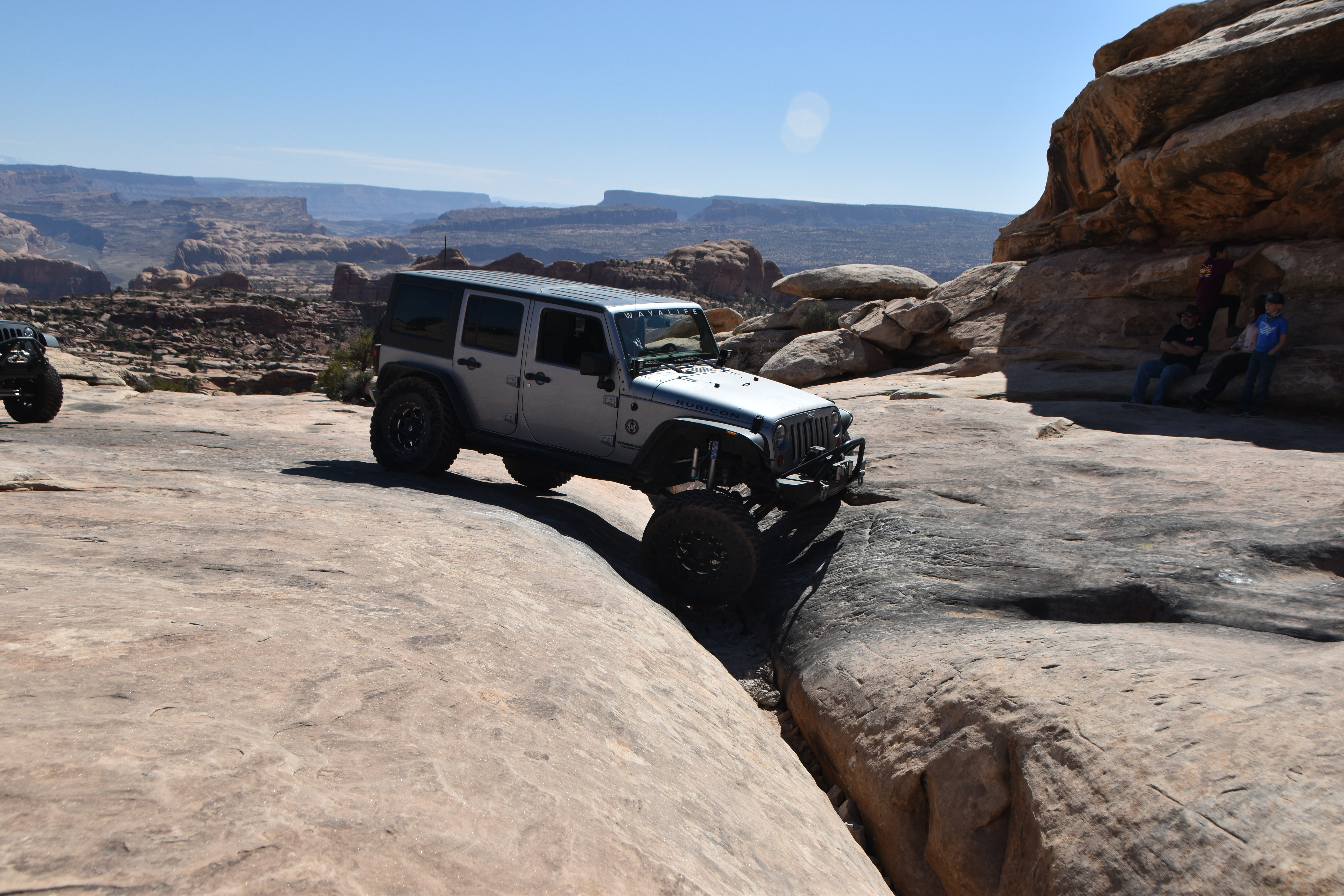
The EJS event was not as huge as in past years because Covid still had some restraints on gatherings in Utah but it was big enough and absolutely as fun on the trails. Jack and I participated in 3 days of 4-wheeling on 3 different trails - Flat Iron Mesa, Golden Spike and Copper Ridge. Along with driving some Jeep trails we enjoyed once again touring downtown and revisiting some of the beautiful scenic areas around town.
Trail 1: Flat Iron Mesa trail had massive views of the snow capped La Sal Mountains and lots of cliffs and canyons. The trail obstacles were just enough to keep us alert and still have fun.
 |
| Scenic views from Flat Iron Mesa |
 |
| Crawling down the ledges |
 |
| Some rocks on the trail |
 |
| Just us. La Sal Mtns in background |
Trail 2: Golden Spike Trail had lots of slickrock, solid rock ledges, broken rock and dirt plus some very vertical sections. It had obstacles named Skyline Drive, Golden Crack, Golden Steps, The Wall, Double Whammy and Body Snatcher and we made it through them all. Yeah!
 |
| Taking the stairs |
 |
| Crossing Golden Crack |
 |
| This way to the Launching Pad obstacle. |
Trail 3: Copper Ridge Trail skirts the boundary of Arches National Park and was mostly dirt and rocky roads with a couple of stretches of slickrock and sandy wash bottom.
 |
| Klondike Bluffs - Can you see the Tower Arch in the middle of the photo? |
 |
| Good bye to Moab until next time |
Once EJS was over we had an invitation to join some of the members of the Western Slopes Four Wheelers from Montrose, CO for a 3 day trail run near Kingman, AZ. Heck yes! But before we headed to Kingman we enjoyed some down time near Bluff, Utah driving the dirt roads and hiking to Native American sites. The Butler Wash along the Comb Ridge area near Bluff is packed with Native American history and we did a couple of the hikes to explore the area on foot.
 |
| Double Stack/Balcony House ruins |
 |
| Corn cobs still remain in the storage granary. |
 |
| Hand prints line the wall. If only the walls could talk. |
 |
Butler Wash Ruins is an Ancestral Puebloan (Anasazi) site & is
considered of the Pueblo III era constructed in the 1200's. |
 |
| More Butler Wash Ruins |
 |
| Monarch Cave Ruins are also Anasazi cliff dwellings |
 |
Lots of broken pottery, shards and corn cobs have been found
and left at the site. |
Also not far from Bluff is the Valley of the Gods, a 17 mile dirt road loop. The loop features a number of monoliths made from sandstone dating 250 million years old. Navajo interpretation of Valley of the Gods rock formations is that the rock formations are places of power in which spirits reside.
 |
| Seven Sailors in the background |
 |
| The vast beauty is breathtaking |
 |
| Setting Hen Butte
|
Of course there are geocaches along the route and one happened to be a heck of a risky climb and retrieval but Jack and I were up for a challenge. You will see from the photo below that the geocache container is safely sitting on a shelf of a large monolith formation.
 |
The arrow is the location of the cache ammo box. Look how small the vehicles
are near the road where we parked. |
After a couple days at Bluff, Utah we loaded up and headed to Kingman, AZ to meet up with friends to do some more off-roading. We happily joined four other couples to explore around the Kingman area.
Day 1 - Chloride Mines Trail, Packsaddle Mountain Loop and El Dorado Trail.
 |
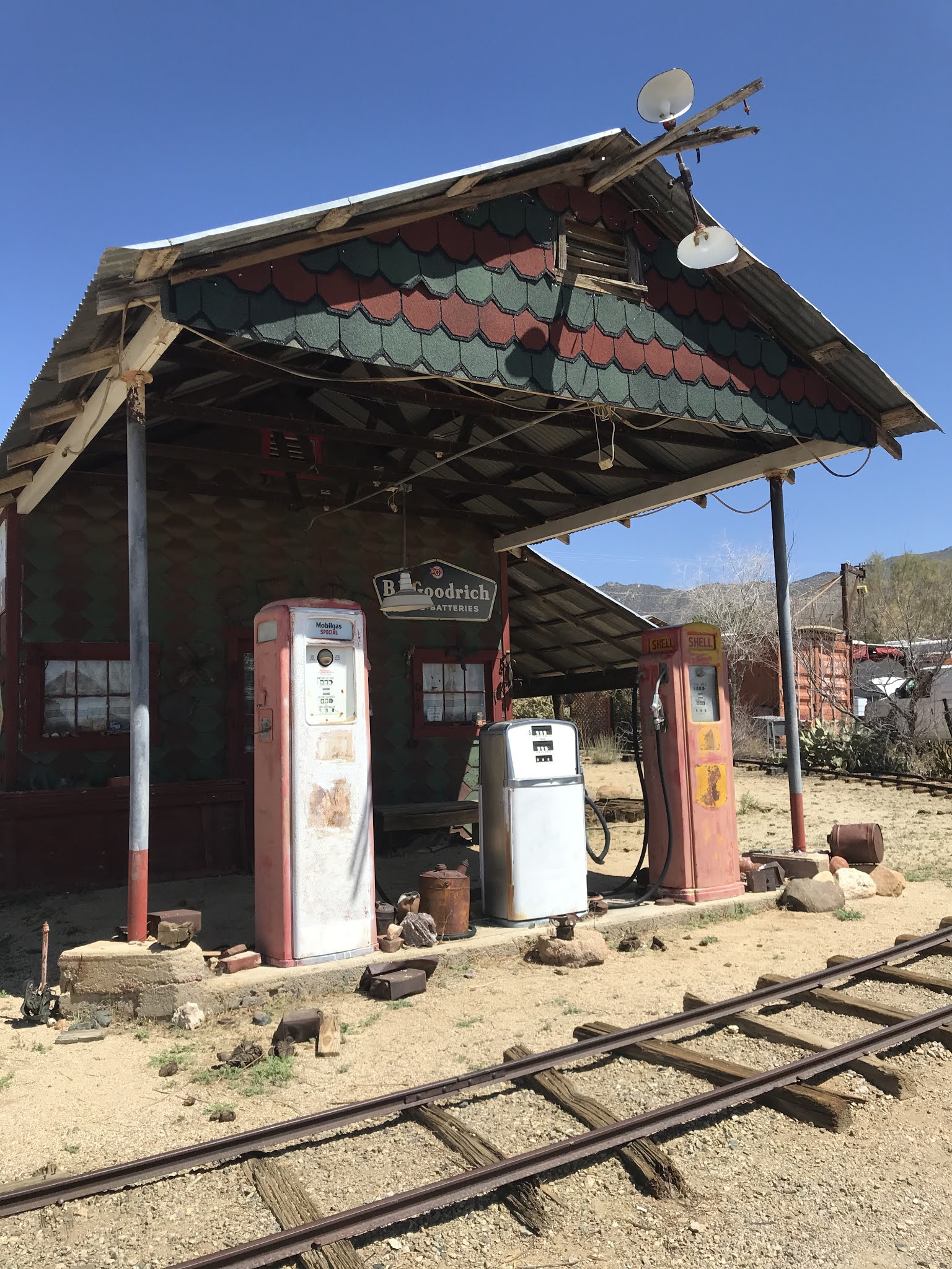
Old gas station in the Town of Chloride, AZ
Chloride, established in 1863, is the oldest continuously inhabited mining town
in the state of Arizona. |
 |
Unique painted rock murals by notable Roy Purcell
completed in 1966. Some very interesting murals along
our trail. |
 |
| Roy Purcell murals |
 |
| View of Mineral Park Mine started in the 1870s and still in operation today. |
Day 2: Hualapai Mountains Trail climbs above 7,000 feet and we enjoyed the cooler weather and pine tree lunch spot. We visited the historic Boriana Mine structures and foundations and found a large display of mining buildings. To our surprise we found GOLD! Or should I say GOLDFISH in a nearby pond.
 |
| Hualapai Mtn. trail |
 |
Historic Boriana Mine. Tungsten, gold, silver and copper
were mined from this area. |
 |
| Goldfish in a year round spring fed pond. |
Day 3: Portland Mine Trail offered us more remote desert trail driving while weaving through rock formations and mining areas until we reached the waters edge of Lake Mohave. Portland Mine was an open pit gold mine probably started in the early 1930's as an underground and surface mine.
 |
| Portland Mine Trail |
 |
| Rest stop along the trail |
 |
| Portland Mine pit. |
 |
We all enjoyed the water at the end of the trail including
Liane and her dog, Eddie.
|
After all the off-roading was done we stayed an extra day to play tourist and also find some geocaches in the area. Kingman, AZ has a lot of Route 66 history and we enjoyed taking some time to read about the history of the area.
 |
| Route 66 - I'll take the red one please. |
 |
The town is dotted with amazing murals.
I especially like this train on the water tower
along Route 66.
In Locomotive park sits steam engine #3759 built in 1928.
|
 |
| This engine is huge! Look at the size of the driver wheels. |
 |
Built in 1909-1910 old Mohave County jail is now
surrounded by modern courthouse buildings. |
 |
Sign on old Jail.
|
Well, I guess that is about all we have to share. We hope you enjoyed this outing as much as we enjoyed sharing it with you. As Johnny Cash said 'I hear that train a comin' It's rolling round the bend' - So I guess we better move on down the road.
Happy Travels,
Jack and Deb