UnCaged Travels

Monday, August 21, 2017

Black Canyon of the Gunnison National Park - revisited

Black Canyon of the Gunnison National Park
East Portal Road
Gunnison Tunnel
August 20, 2017

We decided to revisit the nearby Black Canyon of the Gunnison National Park to see the things we missed the first time two years ago.  Of course, we did take time to revisit the overviews for the Black Canyon of the Gunnison.  The walls of the canyon are unique with the different rock formations.  These rocks blend from one to another because of variations in the heat and pressure which occurred when some rocks were buried deeper than others.  It all sounds highly scientific to me but all means that these transformations began over millions of years ago because of extreme heat and pressure squeezing some rocks between and through other rocks.  It is interesting to know that most of the rocks exposed along the length of the Black Canyon are at least 500 million years old and have a wide of variety of minerals. Go to the park website if you want a more in depth description of the history.


The East Portal Road is extremely steep road with sharp turns and 16 percent grades that switchbacks down the canyon to the Gunnison River.  Once at the bottom you are at the rivers edge and also the beginning of what is called the Gunnison Tunnel.  The Gunnison Tunnel is a 5.8 mile (9.3 km) irrigation tunnel constructed between 1905 and 1909 by the Bureau of Reclamation. At the time of its completion, it was the longest irrigation tunnel in the world.  On July 22nd, 1979, the Gunnison Tunnel was entered into the National Register of Historical Places.  We were not able to get close to the opening of the tunnel as it is fenced off from the public but I did find an online photo of it.  The history of the tunnel and the town of East Portal is also a good history read if you so desire.

Entrance to Gunnison Tunnel  (taken from internet)
 
Entrance to Gunnison Tunnel on left just after the buoys.


Entrance to Gunnison Tunnel on right between buoys and buillding


We had heard that the fishing was good at this location and that bear sightings were reported. Well, we did not fish. We will leave that for another day.  BUT ..... we did see bears.  FOUR BEARS TO BE EXACT.  This made my heart sing with excitement.  I just love wildlife sightings.

Our first sighting was a bear swimming across the river.  Once it reached the other side it had its nose in the air intensely searching for something that it was smelling.  Shortly it gave up and back across the river toward us it swam.  We were out of the Jeep but quickly hustled to the Jeep when it reached our side of the river bank.  It went right by our Jeep and travelled up the road until it came to a clearing where it could escape into the sparse trees.  WHAT A RUSH.


The second sighting was a momma bear and two cubs crossing the road.  We did not want to get between the momma and cubs so we stopped way before we were close to them.  The cubs were slow about crossing the road.

First baby bear slowly crossing the road. Momma is already in bushes and trees.

Momma Bear


Second baby bear finally out of the road.
 It was a great day filled with beautiful scenery and wildlife.  Plus I was the Rookie Ranger for the day!


 Until next time enjoy your adventure ! 
Posted by Uncaged Travels at 6:28 PM No comments:
Email ThisBlogThis!Share to XShare to FacebookShare to Pinterest

Monday, August 7, 2017

Mile High Jeep Club Annual All 4 Fun, Leadville, CO

Seven Days in Leadville, CO for All 4 Fun - the annual off road gathering organized by Mile High Jeep Club.


What do you get when you combine dirt, mountains, streams, old mines, ghost towns and hundreds of off road enthusiasts - a week of ALL 4 FUN!  We attended the Mile High Jeep Club (MHJC) Summer event called 'All 4 Fun' which was their 51st year of putting on this event which rotates around 4 or 5 locations each year.  We loaded up the RV Friday and arrived  at Leadville on Saturday to register and set up our campsite with about 300 other Jeep / off road lovers. They set up a large tent to gather everyone for raffle drawings, a couple dinners and vendor show to make it a family and group event and they do a good job organizing this event.

MHJC run about 20 different trails ranging from easy to difficult and each one running daily for five days.
 
Thanks to our friend, Bill, we had a camping spot with plenty of room and great views.


1st trip: We started out with Clohesy (Cloyses) Lake (we found two different spellings for this lake & unsure which is correct) which was south of Leadville about half way to Buena Vista. It started out easy on dirt roads going past Clear Lake and up the canyon to Vicksburg and Winfield which are a couple preserved 1880's mining towns that, like a number of old 1880's towns/buildings, are being saved and restored and even being furnished with original items to promote the history of the area around Colorado.
 
Historic town of Vicksburg, CO:


Historic town of Winfield:


We did a couple creek crossing to start the trail.

Made it up to the lake at about 11,100 feet in elevation and very scenic.


2nd trip:  The second day we chose to adventure to Mount Princeton driving about 4 miles along a one lane shelf road.


One of the only true completely clear days and the views at 12,300 feet overlooking Buena Vista to East and the Collegiate 14'teener around and Mount Antero to the West.


Just another couple thousand feet up to the top of Mt. Princeton only accessed by foot.

 
After finishing the group run we drove to another 1880's mining town of St. Elmo, which is also in the stage of being preserved.


Following the creek up to St. Elmo, we enjoyed some great water / creek views.

3rd trip:  The third day we signed up for the  Mount Zion trip and we weren't disappointed with the great views over looking Leadville and Turquoise Lake. (Even though it was a little hazy)


Looking down on Buckeye lake from about 12,200 ft for lunch break.

 
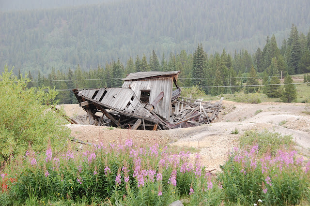
Our bonus trip for the day was taking a road less travelled by exploring and found this old miners cabin.

 
4th trip:  The fourth day was a run called Birdseye Gulch and up to Mosquito Pass. Starting up the shelf road looking down on Birdseye Gulch and Leadville.


Mosquito Pass is the highest drivable pass at 13,185 ft, and as we drove slowing up to the summit a cold front blew through and we were driving through cold wind, snow and hail for a few minutes.


About 2 miles over the pass we stopped at the North London mine and tram house.

 
After coming down we did some more exploring of the old Leadville mining area and checked out some old cabins.

Interior of one of the buildings equipped with stove and original ceiling cloths and old wall paper.
 
The area had an abundance of old mines that dot the area which were fun to explore.


Final trip:  The last day we went on Half Moon Creek trail.  This trail had water crossing, great views and amazing mills and mines throughout the area.


At the head waters we came on to the Champion Mill site which is one of the largest mills around in great shape.

It started in the 1880's and ran up in to the early 1900's and still has equipment inside the mill.


We then went on up to the Champion Mine at about 13,000 ft. where they ran a tram system to get the ore down to the mill and a view looking down on Independence Pass road.


The inside of the mine cabin / bunk house with the stove still in place.

Nice view from the mine cabin.
 
Some of the wildlife and flowers on the trail


A view back down on the large mill building

Coming off the trail at the water crossing.

The event ended on a week of great trail runs and we had to head home. Until next year  which is being held at Silverton, we had fun and thanks to MHJC for the great event.
Hope you enjoy the photos.       
 
Happy travelling ! 
 
Posted by Uncaged Travels at 7:24 PM No comments:
Email ThisBlogThis!Share to XShare to FacebookShare to Pinterest
Newer Posts Older Posts Home
Subscribe to: Posts (Atom)

About Us

My photo
Uncaged Travels
Jack and I are enjoying our retirement and we are loving the freedom to travel in our motorhome so we can experience the outdoors by hiking, 4-wheeling or taking time to get 'uncaged' from our past working lives.
View my complete profile

Blog Archive

  • ►  2025 (3)
    • ►  May (2)
    • ►  April (1)
  • ►  2024 (2)
    • ►  April (2)
  • ►  2023 (7)
    • ►  September (2)
    • ►  August (1)
    • ►  May (2)
    • ►  April (1)
    • ►  March (1)
  • ►  2022 (2)
    • ►  April (2)
  • ►  2021 (3)
    • ►  September (1)
    • ►  August (1)
    • ►  April (1)
  • ►  2020 (5)
    • ►  September (2)
    • ►  August (2)
    • ►  July (1)
  • ►  2019 (10)
    • ►  October (1)
    • ►  September (3)
    • ►  August (1)
    • ►  July (2)
    • ►  May (2)
    • ►  January (1)
  • ►  2018 (7)
    • ►  October (1)
    • ►  September (2)
    • ►  August (2)
    • ►  April (2)
  • ▼  2017 (6)
    • ►  October (1)
    • ▼  August (3)
      • Black Canyon of the Gunnison National Park - revis...
      • Mile High Jeep Club Annual All 4 Fun, Leadville, CO
      • Jeep ride through Engineer Pass near Silverton, CO
    • ►  July (1)
    • ►  June (1)
  • ►  2016 (11)
    • ►  October (1)
    • ►  September (2)
    • ►  August (2)
    • ►  July (4)
    • ►  June (2)

Our Uncaged Family

Our Uncaged Family
Angel's last adventure was January, 2017. We miss our travel buddy.

2013 Jeep JKU

2013 Jeep JKU

2003 National Motorhome

2003 National Motorhome

Blogs we follow

  • good-times-rollin
    Cool Summer Nights
  • ADVENTR.co » // Adventures and Photography from the Colorado Plateau, Rocky Mountains & Beyond
    Wildcat Trail: Unaweep Divide to the Gill Creek Divide
  • GoneByRV
    Black Canyon of the Gunnison, Hiking and Touring

Please join us as Followers

Simple theme. Powered by Blogger.