After all the EJS festivities ended at Moab, Utah we joined up with some of our friends with the Montrose Colorado based Western Slope 4 Wheelers club in Kanab, Utah. We enjoy meeting up with this good fun group of friends that like to four wheel and have fun doing it just like us.
We arrived at our RV site in the Grand Plateau RV Resort. Shortly after setting up 'camp' we promptly went to the Kanab local family owned, Escobar's Mexican Restaurant, for dinner. We are happy to say they have always served delicious food and kind service and still do! With our bellies full, we returned to the RV and prepped for the next day's adventure.
 |
| Site M43 - Home Sweet Home |
The next couple of days were packed with fun dirt road adventures which also included arches, a cemetery, slot canyons, four wheeling and short hikes. We drove the Cottonwood Canyon Scenic Backway, Johnson Canyon Road and House Rock Road. Kanab has so much to offer when it comes to beautiful scenery. These adventures are only a small part of that surrounding area.
Cottonwood Canyon Scenic Backway: The destination for the day was Grosvenor Arch, however, the easy Cottonwood Canyon road was the straight line route but this wasn't the way a group of four wheelers were settling for. The leaders took the more scenic route through Coyote Wash and up and over the switchbacks to some great elevated views of Coyote Wash and extending into Cottonwood Canyon with its spring green cottonwoods and colored clay foothill scenery. The good four wheeling and colorful scenery were definitely a bonus.

|
Grosvenor Arch is actually two sandstone arches (double arch) towering about 150ft
above the ground. It is located in the Grand Staircase Escalante National Monument. |
After a day of exploring Cottonwood Canyon some of the group also stopped at the Toadstool Hoodoos Trail on the way back into Kanab. The round trip hike was about 1.6 miles with the trail being mostly sandy soils. These formations are name Toadstools because they have spire like features with a boulder perched atop a pedestal rock like a mushroom / toadstool. The top rock is made of a harder material that doesn't erode as quickly as the rock material underneath it, thus the lower rock erodes faster than the upper making these toadstool looking 'Hoodoos'.

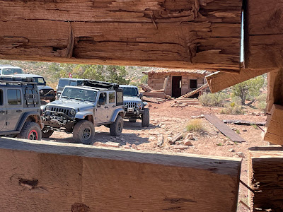
Johnson Canyon Road: This road starts out as a paved road but when you reach Skutumpah Road it turns to dirt. One of the area attractions is the old Gunsmoke film set which is located about 5 miles from Highway 89. The set, however, is on private land and we could not access the property for a more closer look but it was interesting to see some of the remnants from afar. Most of the buildings were dilapidated due to the weather but we could still envision Marshall Dillon and Miss Kitty walking down the dusty main street of 'Dodge City'.
 |
| Old Gunsmoke Film Set through our eyes |
 |
| 2018 photo from Visit Kanab FB page. |
Continuing down the road we arrived at Lick Wash Trailhead. This was our lunch stop and where we also enjoyed a short hike through the slot canyon.
 |
| Lick Wash canyon walls |
 |
| Lick Wash slot canyon |
 |
| Narrow part of Lick Wash Trail |
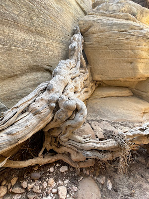 |
| Amazing root system squeezing through the rock wall. |
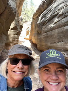 |
| Always fun to share the experience with friends. |
 |
| Lunch time camaraderie (photo by Lynn) |
 |
| Lunch time camaraderie (photo by Lynn) |
We did end the day by taking the road less traveled or otherwise known as the Great Western Trail. The Great Western Trail is a dirt / four wheeling road system from Canada down to Mexico and covers 4,455 miles through Montana, Wyoming, Idaho, Utah and Arizona. It's always fun to drive a part of this historic route whenever we have a chance. We have driven some of the route in Arizona and now Utah.
As we all met for dinner at Iron Horse Restaurant we found there was a poker game going on with some of the locals. It looked pretty intense as the anti was high so we moved on to our table to enjoy a nice dinner and conversation and left them to their game.
 |
| Locals playing poker |
White Pocket, Arizona: Our last group trip we four-wheeled to a beautiful remote place known as White Pocket. This has been on our places to visit list for some time so we were excited to be a part of this adventure. The most challenging part about White Pocket was getting to it. It is located about 1 1/2 hour drive down a bumpy, dusty and some-what deep sandy roads into Arizona. The drive is worth it! Briefly, the White Pocket area is made up of colorful swirls and patterns of Jurassic age white and red Navajo sandstone, which were sculpted over millions of years ago by wind and water erosion. This was an awe-inspiring trip. One that we are glad we didn't miss.


Paria Ghost Town: Once we returned to HWY 89, we aired up our tires from the long bumpy ride to White Pocket and then decided to make one detour to an old ghost town. Paria or Pahreah was inhabited in about 1870 to late 1920s. The settlement experienced many hardships including lack of consistent irrigation for crops and river floods, which washed away structures and crops. In later years the film industry became interested in using the picturesque ghost town as a location for making Western movies. The area is surrounded by colorful Chinle Formation mountains with straited cliffs of bands of red, orange, purple and grey.
 |
Paria town cemetery. In our readings we found out it is a replica, more of a memorial,
as the tombstones and markets are replacements as the originals eroded over time
and prone to vandals. There were many Smith's and Smithson's buried here in the late 1800s. |
Other than the Memorial cemetery, there wasn't much left to even let you know there was a town in this area and even the large scale film sets had been removed and some burned by vandals. Just a nice scenic drive into the Paria canyon.
As the saying goes - all good things must come to an end but we have enjoyed our adventures around Southern Utah and hope to continue more in the future.
Thanks for reading. Wishing you many great adventures of your own.
Jack and Deb
We'll close with some lyrics from an ole' Marty Robbins song entitled 'The Red Hills of Utah'.
How green are the valleys
How tall are the trees
How cool are the rivers
How soft is the breeze
If it's just like my dreams
Then I must go and see
For the red hills of Utah are callin' me


.jpg)


.jpg)


