We have been visiting Moab, Utah for years on an annual basis. We keep coming back because of the beautiful landscape and that it is also a Jeepers paradise. Moab's scenery is made up of nearby La Sal Mountains (13,888 elevation), towering red rocks, unique formations, arches and mesa views where you can see for miles. It is home to two National Parks and boasts of being a mecca destination for all types of outdoor enthusiasts including hiking, biking, off-roading and river rafting to name just a few activities.
This was our 13th year to attend the Moab Easter Jeep Safari and it's 59th year of existence. Again, it did not disappoint. As we usually do, we embarked on our own journeys to explore trails and geocache around Moab, plus participated in EJS scheduled activities. From driving dusty roads to dining at Sunset Grill overlooking Moab we were once again blessed to experience this grand area.
We began our adventures driving Deadman Springs trail. The trail was made up of dirt, sand and rock sections with an occasional ledge to make it interesting. Legend has it that in the 1890's two cowboy's found a dead cowboy at the springs - hence the name Deadman Springs.
.jpg) |
| Lunch spot in the area of Deadman Springs. |
Another trail that we had never explored before was Devil's Racetrack Trail. It is about 90 miles from Moab and closer to the town of Green River, Utah. The trail itself is in the Eagle Canyon and Coal Wash Wilderness areas. It's a spectacular area with canyon views, sandy wash bottoms, unlimited rock formations and a couple trail obstacles to conquer.
 |
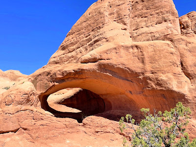
| See the arch? It's technically called a window. |
 |
| La Boca Arch |
 |
| Dinosaur Tracks, one of the three toes doesn't have water in it. |
 |
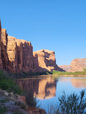
View from our lunch stop overlooking the Colorado River and Professor Valley.
|
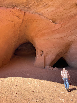 |
| After lunch, we stopped at Cave Springs. |
 |
The remains of an old mining camp. Cabins were built with old
railroad ties that still had the rail spikes in them. |
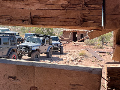 |
| Mining camp |
 |
| Nearby was the mine entrance - Did we go in? |
 |
Yes we did. The trail leader had a Geiger-counter with him which read the radiation level.
Most of the time it was at safe levels but got higher the deeper into the mine we walked. |
 |
This was only a short distance into the mine. We could see
that it continued on but that would be unsafe.
|
In between all of the scheduled planned activities we went out on our own to do some exploring. We found rock formations rarely visited, petroglyphs and geocaches.
It's been years since we drove the Long Canyon Road so we thought we would do the drive again and collect a couple of geocaches along the way. The majority of this trail is pretty smooth; however, there are a few bumpy sections, shelf road sections and also narrow sections. The section called Pucker Pass is where is gets both narrow and bumpy. It was named Pucker Pass by some Jeepers back in the days when the drive down the canyon was a lot more challenging than it is now.
 |
Jug Handle Arch at the mouth of Long Canyon
|
 |
| Challenge #1... The narrows into Pucker Pass in Long Canyon Road. |
Challenge #2...Fallen rock that you have to drive under.
 |
Once you reach the highest point along the Long Canyon Drive
you are welcomed by breathtaking views of La Sal Mountains
and rock cliffs. |
Another day, we enjoyed combining geocaching and Jeeping which brings us to great scenic locations and fun 4-wheeling adventures.
.jpg) |
Geocaching brought us to this off the beaten
path of this Spiral Formation. |
 |
Again, a geocache brought us to this old cabin made of railroad ties. Located in the
Dubinky Well area we needed to drive up a wash to get to it where we found the cabin
located right on the edge of the wash. The only inhabitants now are the pack rats. |
We enjoyed a drive along the very scenic Potash Mine road which follows along the Colorado River. All throughout the area are hiking trails, tall red rock walls, petroglyphs and even rock climbers scaling the vertical cliffs right beside the roadway.
 |
| We had the Colorado River on one side and sandstone cliffs on the other. |
We also stopped at some interesting petroglyphs as we drove down Seven Mile Canyon road.
 |
Petroglyphs showing bighorn sheep with rectangular bodies and
also found a nearby cache.
|
 |
In the same area as the sheep we viewed Pictographs of human-like
figures painted on the rocks. The middle, more decorative image,
is known as Intestine Man, because if you zoom in, it looks
like intestines. |
It was another successful Easter Jeep Safari with many miles of dirt and sandstone passing under our tires. Next, we leave Moab and on to some more Jeeping adventures where we meet up with our friends with Western Slope 4-Wheelers to explore Kanab, Utah.
Happy Trails!
Jack and Deb
"Adventure is out there." - Up (movie)
.jpg)


.jpg)


No comments:
Post a Comment